

 Australia
  Brazil
  Canada
  Chile
Chile  China
China  Columbia
  Denmark
  Egypt
Egypt  France
  India
India  Indonesia
  Ireland
  Italy
Italy  Malaysia
  New Zealand
  Norway
  Panama
  Peru
Peru  Poland
  Portugal
  Saudi Arabia
  Singapore
  South Korea
  Spain
Spain  Sweden
  Taiwan
  Thailand
  Türkiye
  United States
  Vietnam
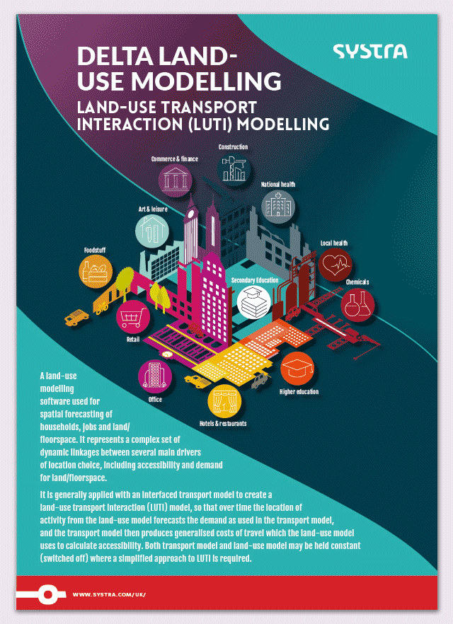
 A land-use modelling solution for spatial forecasting.
Delta is the digital platform that is at the forefront land use modelling and forecasting. Its bespoke engine provides in-depth analysis of how households and businesses respond to changing urban, demographic, and economic dynamics.
Developed over many years to meet your needs, Delta supports every stage of your study, from initial analysis to strategic decision-making.
With visualisations, interactive dashboards, and GIS integration, Delta enhances your data and clarifies your choices, whatever the size or complexity of your area. It delivers powerful insights into the impact of your transport projects and the connections between jobs, housing, and mobility.
Related services
delta – Features
Comprehensive vision and dynamic interactions
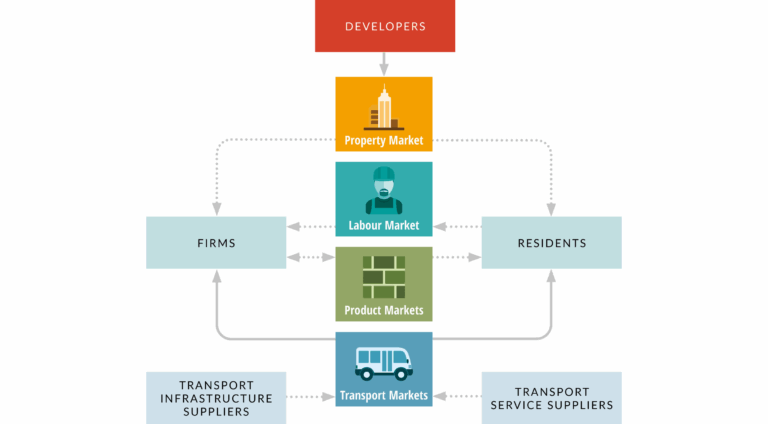
Delta offers a holistic framework that captures the complex, dynamic interactions between key actors shaping cities and regions—including developers, firms, residents, service suppliers, and transport providers.
By modelling connections across property and labour markets, infrastructure, and product markets, Delta reveals the far-reaching impacts of each actor’s choices, supporting evidence-based, integrated planning.
Advanced location choice modelling
Delta models a dynamic set of linkages between core drivers of location choice, including:
- Accessibility
- Demand for floorspace
- Job opportunities
- Housing rent
- Quality
Delta is particularly valuable for assessing investments whose benefits extend beyond purely transport-related outcomes. The model helps to address questions relating to economic growth and transformation, urban regeneration, the social and spatial distributional effects.


A flexible, customised solution
Each Delta deployment is tailored for your objectives:
- Usage and application context
- Customisation to local and strategic priorities
- Defined performance indicators
Choose a fully supported turn-key solution or integrate Delta directly into your organisation for internal users been developed to significantly improve the way the user can interact with the model outputs.
Enhanced user experience
Thanks to the latest advances in data science, Delta now offers customisable, presentation-ready reports for stakeholders. Models can be built, calibrated, interrogated, and ultimately presented to clients and stakeholders. In addition, various options are available for those requiring access to land-use modelling software.

Drive better project outcomes
The Delta solution offers a comprehensive set of benefits designed to improve land-use and transport planning strategies. The use of the solution allows you to:
- Conduct initial analyses and policy studies: quickly assess the impact and potential benefits of any new initiative.
- Develop forward-looking scenarios: Easily visualise and compare the effects of various demographic, economic, or traffic changes.
- Support strategic planning: Access a robust set of relevant indicators and metrics to guide and secure your decisions.
- Prioritise, structure, and review your projects: Simulate a wide range of standalone or combined projects and benefit from objective comparisons to identify high-potential areas.
- Perform in-depth economic analyses: Go beyond traditional approaches and obtain comprehensive, detailed results.
- Support strategic studies: Provide concrete evidence to substantiate your assumptions and guide your scenarios.
- Carry out rigorous evaluations: Give precise, fact-based answers to counterfactual questions to demonstrate the added value of your actions.
What is a Land-use Transport Interaction (LUTI) model?
A LUTI model captures the two-way feedback between land use and transport. Transport networks shape accessibility, which influences where households and firms choose to locate; those location choices change land use patterns and demand for travel, which then affect congestion, service levels, and future transport investment. LUTI models formalize this feedback to analyse current conditions and forecast outcomes under alternative policies. Delta endogenises these connections to provide a realistic simulation of urban change over time.
Why use Delta instead of traditional transport modelling?
Traditional transport models excel at forecasting travel demand, mode and route choices, and network performance under defined land-use assumptions. However, they are typically ‘static’ with respect to land use: accessibility changes are treated as outputs, not drivers of future location decisions.
Delta adds what conventional models omit:
- Dynamic land-use responses. Delta captures how accessibility shifts influence where households and firms choose to locate, how developers respond, and how these choices evolve over time.
- Integrated markets. By modelling interactions across the property and labour markets, Delta links transport improvements to housing supply, prices/rents, job distribution, wages, and commuting patterns.
- Long-term trajectories. Rather than a single snapshot, Delta simulates year-by-year pathways, revealing lagged effects, path dependency, and cumulative impacts.
- Support Complex Business Cases. where land use and dynamic impacts are significance.
How can I forecast the long-term impact of transport on urban growth?
SYSTRA provides the Delta modelling solution to simulate the relationship between infrastructure, housing, and jobs. It gives you the evidence needed to predict how transport projects will shape future land use and development.
Can the system be customised for regional requirements?
Yes. Delta is designed to be customized for regional contexts and requirements. We tailor every deployment to your objectives. SYSTRA can provide a fully supported solution or integrate the analytical environment directly into your organisation for internal use.
Bridge the gap between mobility and growth
Delta bridges mobility and growth by quantifying how transport investments impact where people live, work, and invest—turning accessibility changes into clear forecasts of development, jobs, housing, and land values. By capturing the feedback between networks, markets, and land use, it reveals the dynamics that traditional transport models leave out, so you see not just how people move today but how places will evolve tomorrow.
With this evidence in hand, you can target infrastructure where it delivers the greatest, most equitable impact, align housing policies with transit, and build credible longterm business cases.
Delta turns complexity into actionable insight—helping you plan smarter, faster, and achieve more sustainable growth.

We’d love to help with your next project

Roberta DAL SASSO
Associate Director

Martin CAMPBELL
Digital Solutions Lead

request a DELTA demo
Insights


- News
4 October 2022
SYSTRA enhances land use modelling capability with Delta acquisition
our Services

- services
Land Use Modelling
Read more sur Land Use Modelling
- services
Land Quality
Read more sur Land Quality
- services
Digital Solutions and Software Development
Read more sur Digital Solutions and Software Development
- services
Local Transport Modelling
Read more sur Local Transport Modelling
- services