SYSTRA applies advanced land use modelling expertise to inform complex decision-making in transport and infrastructure investment and planning – helping to support sustainable development and environmental goals.
Understanding the impacts of infrastructure developments
Planning any new development or transport system involves the evaluation of a huge range of variables to determine the impacts and implications of every decision. The complex interactions between people, transport systems, businesses and the environment need to be assessed so that optimum proposals and policies can be implemented.
Advanced land use modelling systems can be deployed to provide the insight and analysis required to appraise development or investment proposals, and understand the local and wider impacts of different schemes.
The land use consultants at SYSTRA combine proven expertise with robust land use modelling software to help clients appraise integrated transport and development proposals – providing the insights that developers, investors and policymakers need to create well-informed policies, plans and business cases.
our experience
Discover how SYSTRA provides expert insight and advice to support decision making, policy development and strategy.

SYSTRA land use consultants offer a full range of modelling, forecasting and assessment services for integrated land use and transport system proposals.
Policy and planning proposal analysis
Our land use modelling consultancy services offer unique insights into the analysis and appraisal of development proposals and planning policies. Combining our consultancy skills with the capabilities of our advanced DELTA modelling software, we help clients to understand the impacts of proposals on a geospatial basis – quantifying impacts on households and employment levels, as well as assessing the economic benefits.
Land use and transport interaction modelling
We can assess urban developments alongside integrated transport proposals, enabling us to model the complex interaction between land use and transport systems. We help clients to fully understand the impacts and benefits of any proposal at a local, regional or national level.
Such integrated land use and transport modelling can help planners to address a city or a region’s longer-term challenges, so that stakeholders can work towards a shared vision for the future – and coordinate investments and policy decisions to achieve that vision. As set out in the Climate Change Committee’s advice, integrated land use and transport planning is now recognised as being a critically important part of reducing transport emissions.

AREAS OF EXPERTISE
The SYSTRA land-use modelling team is a hugely experienced group, passionate about modelling and dedicated to producing very high quality analytical work for their clients. The team has strong skills including:
- Deploying DELTA models across a wide range of markets including, transport, planning and economic development.
- Exceptional knowledge around the interaction of transport with related markets and the appropriate appraisal techniques.
- The use of LUTI models to support complex business cases where land-use and dynamic impacts are significance/
- The clear presentation of results and core model behaviours through spatially focussed analytical tools including data models, dashboards and GIS.
DELTA land use modelling and forecasting tool
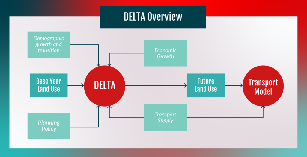
Our DELTA software is a powerful tool for complex land use modelling. At its heart is an innovative locational choice model, which helps to predict how firms and households will behave given changing conditions. We use the software to understand the impact of transport proposals on a whole range of wider markets, so that the web of interactions can be better understood.
The DELTA tool is designed for use at all stages of the appraisal process, as well as to help inform appraisal development. Through a variety of visualisations, dashboards and GIS tools, the system presents data in user-friendly formats to help empower clients with the information they need to make well-informed decisions.

Long-term benefits of land use consultancy
Ultimately, SYSTRA land use consulting services enable clients to objectively and quantitatively appraise proposals, and understand the implications of different planning and policy decisions. Our expertise combined with land-use modelling software enables clients to explore the complex dependencies within any integrated planning proposal. It helps clients to understand the long-term dynamic impacts of transport and infrastructure investments, and highlights constraints and impacts in a wide range of connected markets.
How can our experts help?
you may also like

Find out what its like to work at SYSTRA, rewards, benefits and about different career pathways including apprenticeships and graduate opportunities.
 Australia
  Brazil
  Canada
  China
China  Denmark
  France
  India
India  Indonesia
  Ireland
  Italy
Italy  Malaysia
  New Zealand
  Norway
  Poland
  Saudi Arabia
  Singapore
  South Korea
  Sweden
  Taiwan
  Thailand
  United States
  Vietnam

