

 Australia
  Brazil
  Canada
  Chile
Chile  China
China  Columbia
  Denmark
  Egypt
Egypt  France
  India
India  Indonesia
  Ireland
  Italy
Italy  Malaysia
  New Zealand
  Norway
  Panama
  Peru
Peru  Poland
  Portugal
  Saudi Arabia
  Singapore
  South Korea
  Spain
Spain  Sweden
  Taiwan
  Thailand
  Türkiye
  United States
  Vietnam
 Predictive AI-enabled road safety and geospatial analytics

Collision Seek helps save lives on Britain’s roads by identifying where serious collisions are more likely to occur before they happen.
Historically, road safety improvements have relied on reactive analysis of collision hotspots, with action taken only after incidents occur. Developed by SYSTRA and funded through a Transport Research and Innovation Grant from the Department for Transport, Collision Seek is an AI‑enabled road safety analysis tool for Great Britain’s road network.
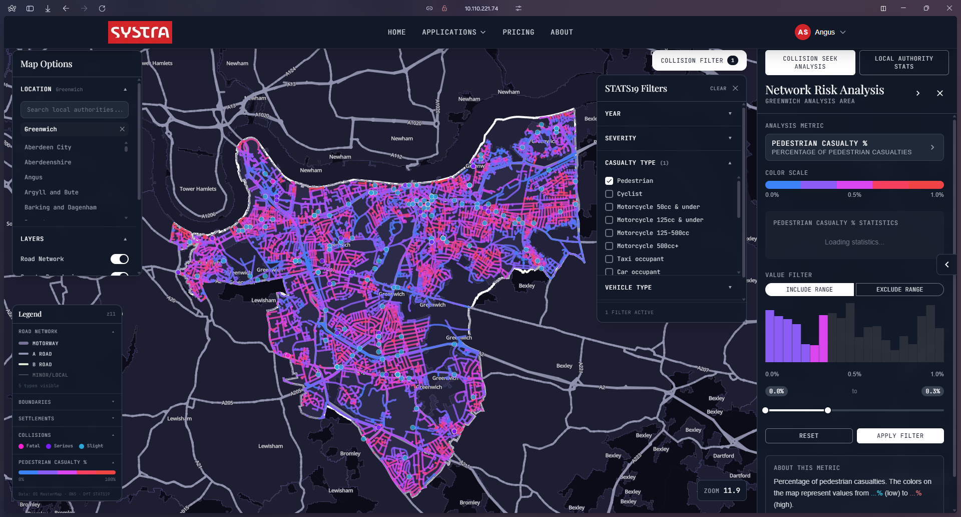
Collision Seek analyses the ‘DNA’ of the road environment by identifying the specific physical characteristics associated with collision risk. Collision Seek enables authorities to identify high-risk locations and implement preventative measures before collisions happen.
Related services
How Collision Seek Works
The predictive analysis framework
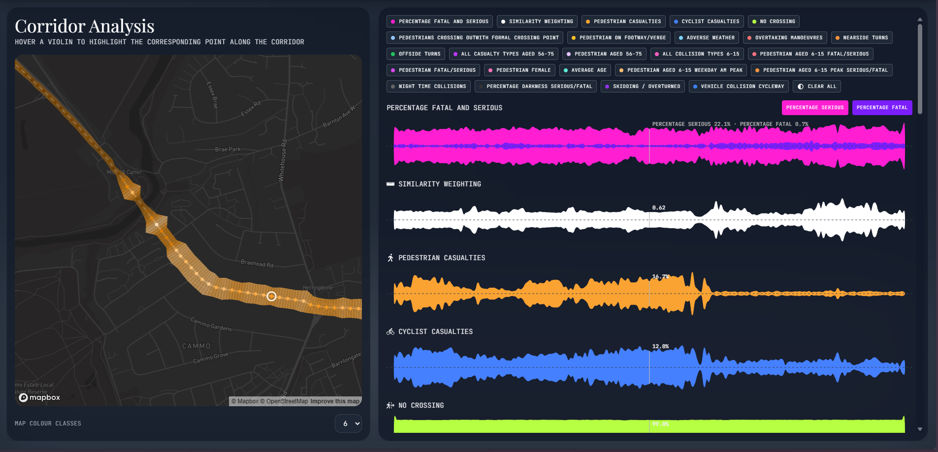
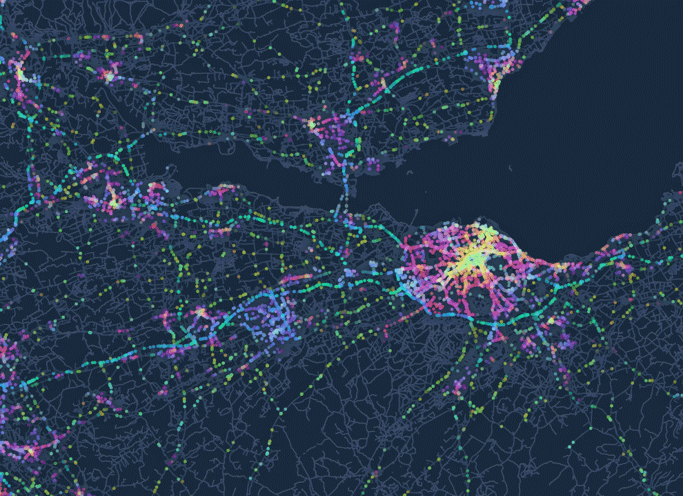
Collision Seek follows a three-stage predictive analysis framework. It aggregates STATS19 collision data across similar physical environments nationwide. It then analyses key physical features such as road markings, pedestrian crossings and buildings to understand collision risk patterns. The tool finally evaluates relative risk across entire road systems to identify locations where specific users are most vulnerable – including pedestrians and cyclists.
Precision geospatial intelligence
Collision Seek estimates the likely types and severity of road collisions anywhere in Great Britain. By layering diverse geospatial datasets with nationwide collision patterns, the tool provides the technical evidence base to confidently prioritise, target and evaluate the most effective safety interventions and investment.
This approach is particularly valuable in areas with limited collision history, where traditional reactive analysis fails to identify emerging risks.
Key features
- Interactive GIS dashboards – Visualise road collision risk across your network with clear maps showing high-risk corridors and junctions.
- Road network risk evaluation – Assess entire road systems or focus on individual junctions to identify where specific users are vulnerable.
- User group risk analysis – Identify elevated risk locations for pedestrians, cyclists and other vulnerable road users, including child vulnerability mapping.
- Road environment profiling – Match your locations to similar environments nationwide, turning sparse local collision data into robust, actionable risk insight.

Vision Zero and the Safe System approach
Collision Seek supports authorities in achieving ‘Vision Zero’ – the goal of eliminating all road deaths and serious injuries. The tool complements the Safe System approach outlined in the DfT Road Safety Strategy.
These systems focus on improving road environments that reduce the likelihood of human error that leads to fatal or serious injuries – for which Collision Seek is uniquely placed to help inform.
How does Collision Seek improve safety in areas with sparse or stochastic collision data?
Where local collision data is limited or highly variable, traditional hotspot analysis can struggle to provide a reliable evidence base. Collision Seek overcomes this by matching your locations of interest to similar physical environments nationwide, turning sparse local records into robust, actionable risk insight so UK local authorities can act proactively
Can Collision Seek identify risks for pedestrians, cyclists and other types?
Yes. Collision Seek evaluates relative risk across the wider road network to show where pedestrians, cyclists and other vulnerable road users are most exposed. This supports targeted mitigation such as child vulnerability mapping, safe routes to school planning and strategic active travel and cycling investment in Great Britain.
What role does machine learning play in Collision Seek?
Machine learning underpins Collision Seek’s analysis of road character, learning patterns from features such as geometry, markings, crossings, buildings and vegetation linked to past collisions. This helps local authorities and highway agencies in Great Britain prioritise and target the most effective safety interventions, supporting better return on investment and helping to save more lives.
What is STATS19 collision data and where does it come from?
STATS19 is Great Britain’s official dataset of personal injury road collisions reported to police forces across England, Scotland and Wales, including Killed or Seriously Injured (KSI) casualties alongside slightly injured cases. Police collect the data using the standardised STATS19 form for collisions on public highways that result in death or injury. The Department for Transport (DfT) then validates and publishes it annually as the primary national road safety statistics.
Achieving measurable road safety improvements
Collision Seek harnesses nationwide evidence and machine learning to help you improve road safety and infrastructure, secure funding with confidence, and protect vulnerable users proactively across Great Britain’s road network.
Book a demo and talk to our specialists about your road safety challenges.
We’d love to help with your next project

Martin CAMPBELL
Digital Solutions Lead

Angus SPENCE
Principal Consultant

request a demo of collision seek
Insights

our Services

- markets
Highways & Roads
Read more sur Highways & Roads
- services
Traffic Engineering and Road Safety
Read more sur Traffic Engineering and Road Safety
- services
Digital Solutions and Software Development
Read more sur Digital Solutions and Software Development
- services
Local Transport Modelling
Read more sur Local Transport Modelling
- services