

 Australia
  Brazil
  Chile
Chile  China
China  Columbia
  Denmark
  Egypt
Egypt  France
  India
India  Indonesia
  Ireland
  Italy
Italy  Malaysia
  New Zealand
  Norway
  Panama
  Peru
Peru  Poland
  Portugal
  Saudi Arabia
  Singapore
  Spain
Spain  South Korea
  Sweden
  Taiwan
  Thailand
  Türkiye
  United Kingdom
  United States
  Vietnam
 Transport planning is a discipline that requires technical expertise and strategic vision to develop efficient and sustainable transportation networks. At SYSTRA Canada, we are committed to providing transport planning solutions that meet the complex needs of modern mobility. The following is an overview of the key activities that underpin our approach to transport planning, including modelling, geomatics, data processing, alignment studies, station design and pedestrian flow studies.
Modelling and Simulation: Forecasting the Future of Travel
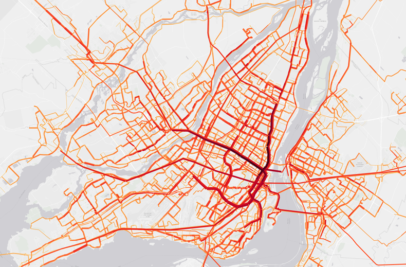
At the heart of transport planning lies modelling, a powerful tool that simulates people’s travel behaviour. At SYSTRA Canada, we use advanced transportation models to anticipate future changes, evaluate various scenarios and optimize infrastructure. Our simulations allow us to analyze traffic flows, travel times, and emissions, providing a solid basis for informed decision-making. In addition, SYSTRA has developed its own modelling software to save analysis time and increase flexibility.
Geomatics: Mapping the Future of Transport Infrastructures
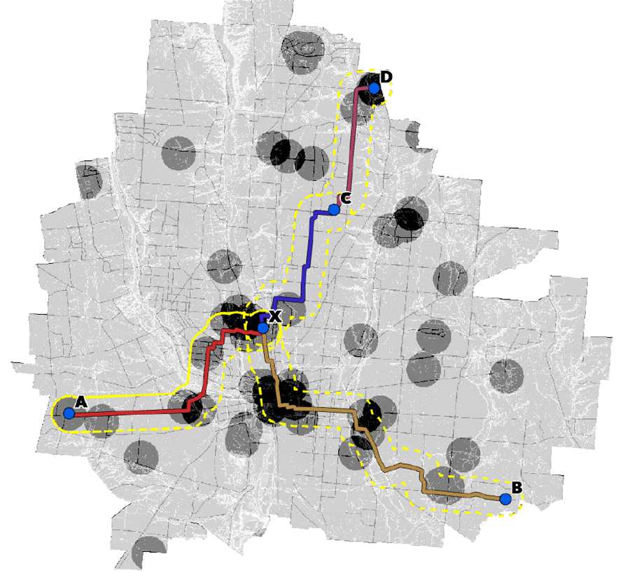
Geomatics is a cornerstone of our methodology, combining geography and IT for precise spatial management and analysis. Our Geographic Information Systems (GIS) facilitate the visualization of transport networks and the mapping of infrastructures, enabling the clear identification of sensitive areas and opportunities for improvement. With its great capacity for innovation, SYSTRA Canada has developed several techniques combining new technologies and GIS to provide new analysis to meet our clients’ needs.
Data Processing: Extracting Knowledge for Better Mobility
Data processing is essential for understanding travel patterns and identifying challenges in the transportation network. We integrate data from traffic sensors, surveys, and geospatial sources to formulate strategic recommendations that improve the efficiency and resilience of the transportation network.
Alignment Study: Designing Optimal Infrastructures
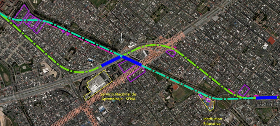
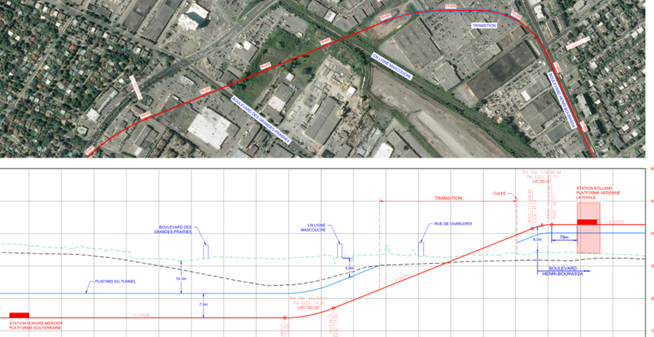
The alignment study is a critical phase that determines the location of transportation infrastructures. We analyze geographical features, environmental constraints, and the needs of the population to define the optimal route. We strive to design infrastructures that meet current and future requirements while minimizing costs and respecting the environment.
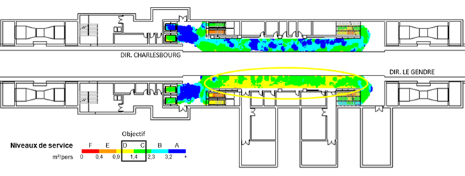
Station Sizing: Creating Efficient Multimodal Hubs
Station sizing is crucial to creating mobility hubs (or multimodal interchange hub) that efficiently manage passenger flows. We analyze demand, design ergonomic spaces and integrate intermodality to ensure fluid connectivity between different modes of transport. Safety and sustainability are also central to our station design.

Block diagram of a railway station
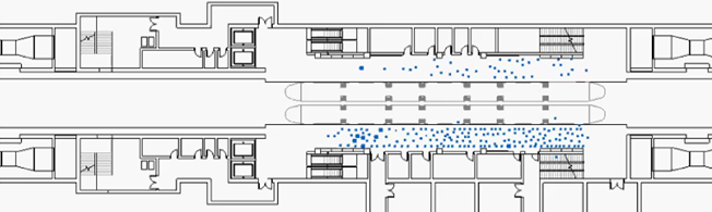
Pedestrian Flow Studies: Ensuring User Safety and Comfort
Our static and dynamic pedestrian flow studies are essential for understanding and anticipating pedestrian movement within infrastructures. We analyze points of interest, observe behaviors and design pedestrian spaces sized to accommodate future flows and traffic. Dynamic studies enable us to simulate flows in real time, analyze temporal variations and integrate interactions with other modes of transport. Safety and emergency evacuation are key aspects of these studies.
Moving Forward with Transport Planning
At SYSTRA Canada, we are dedicated to excellence in transport planning. Our integrated approach and advanced methodologies enable us to meet the challenges of contemporary mobility and design transportation networks that effectively serve communities while respecting the environment. We are proud to contribute to the development of transportation solutions that shape a sustainable and connected future.
COMING SOOON…
Don’t miss our next article on transport modelling!