Achieving ‘net zero’ by 2050 is no easy task, particularly when many local authorities are struggling with limited resources. Yet the UK is legally bound to 2050 and with the Department of Transport (DfT) guidance on Quantifiable Carbon Reduction imminent, it is clear that decarbonisation must be at the heart of transport planning and every Local Transport Plan. So how can local authorities identify which proposed transport interventions will actually cut carbon and by how much? This is where the Decarbonisation Policy Playbook comes in.
The Decarbonisation Policy Playbook is a comprehensive toolkit commissioned by Midlands Connect and developed by SYSTRA in partnership with Atkins, a member of the SNC-Lavalin Group. The toolkit can be used to explore the impact of different interventions and scenarios in reducing Greenhouse Gas (GHG) emissions, helping to create robust evidence-based and data-driven Local Transport Plans. The Playbook is designed to be used by Local Transport Authorities in England, transport policy officers and consultants working on their behalf.
Midlands Connect discovered a knowledge gap: how could local authorities identify the most effective transport interventions that would result in carbon reduction tailored specifically to their area? With the innovative Playbook tool, local authorities can now eliminate the guesswork (and stress), involved in appraising the likely carbon reduction impacts of measures which they may want to include in their local plans.
The Decarbonisation Policy Playbook will help Local Transport Authorities follow the DfT’s recommended approach to the Quantifying Carbon Reduction (QCR) component of the LTP4 process and support with the development of the all-important ‘net zero’ challenge. The Playbook can be considered as a really useful ready reckoner to enable LTAs identify, at a strategic level, the schemes and policies that can be included in their Net Zero strategy. Schemes can then be designed and appraised in detail to make sure that the right interventions will achieve the planned outcomes.

We know that improvements to make sustainable modes – walking, cycling and public transport – more attractive can generate significant increases in the use of these modes, but it is often difficult to find evidence to quantify the corresponding reduction in car kms and any associated reduction in Greenhouse Gas (GHG) emissions. The appraisal of measures including the reallocation of road space from car traffic to sustainable modes needs particular care in order to capture the trade-off between the reduced car kms and any higher emissions per km from traffic that remains. The Decarbonisation Playbook captures these complexities and many other scenarios, so it can help inform initial strategic decisions on what to include or exclude from an LTP.
So how does the Playbook work? Designed for ease of use, the ‘User Interface’ allows users to select interventions and add them to a scenario for analysis. Users can test single interventions or packages of interventions for maximum flexibility. For example, the initial plan might include improvements to walking and cycling networks, improved bus priority, increased parking charges and the introduction of a Workplace Parking Levy in relevant urban centres. The Playbook can be used to answer questions over time such as: will the addition of certain measures reduce the GHG emission rate? The Playbook does the hard graft for its users, behind the scenes, the ‘Calculation Engine’ crunches the numbers and applies the impact of the chosen interventions to vehicle kilometres. Finally, the ‘Emissions Module’ uses the revised future fleet profile proportions to calculate carbon emissions in each future year and generates charts and tables which clearly summarise the predicted carbon reductions over time.

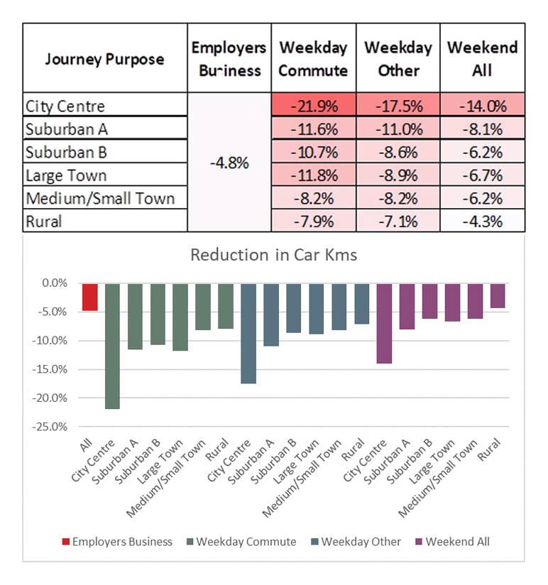
The Playbook is calibrated to predict how geography will affect the predicted impacts of different interventions, with seven place types, ranging from city centres which have constrained parking and higher mode share of public transport and active modes to remote rural areas which have longer-than-average trip lengths and where the alternatives to car use for all but the shortest journeys are limited.
The Playbook uses the local or regional authority’s distribution of place types (based on ONS boundary data or MSOA) to allocate traffic emissions and apply the impacts relevant to each place type. There are typically much lower impacts in rural areas and small towns than in city centres and suburban areas. The Playbook then then fits the jigsaw pieces together to provide an estimate of the change in a local authority’s overall traffic emissions.
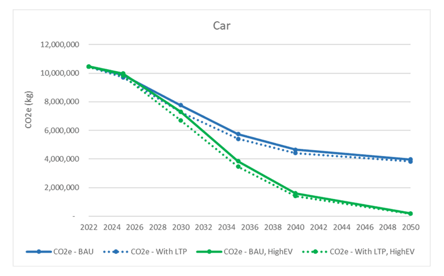
The benefits don’t stop there. The Playbook generates informative outputs, including graphs providing an emissions forecast with the new strategy in place. Users then have the evidence they need to track progress and make informed decisions in accordance with the DfT’s QCR guidance.
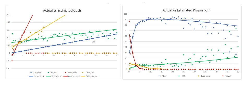
The Playbook is built upon a robust evidence base. It combines case study data from 122 sources selected from a comprehensive ‘Rapid Evidence Assessment’ scoring system with analysis of the mode split patterns of around 1.5 million individual trips recorded by the English National Travel Survey between 2012 and 2019.

The drive to achieve net-zero emissions by 2050 is a crucial step in our battle against climate change, yet the timeframe is relatively short considering the magnitude of the behaviour change required. This powerful evidence-based tool will help manage expectations regarding what can be delivered through a package of ‘carrot-only’ measures and if indeed big ‘sticks’ are required.
With the Decarbonisation Policy Playbook, local transport authorities can plan with confidence and be assured that their estimates of carbon reductions are based on a standardised evidence-base and DfT-approved approach.
If you require assistance with any aspect of your LTP4 preparation including the Quantified Carbon Reduction process, please contact David Connolly at SYSTRA dconnolly@systra.com
1 An additional 0.3 million trips are available to calibrate trips made by residents of the Greater London Area, but the current version of the tool is specifically designed to be applied outside the GLA, so these trips by residents of the GLA have been excluded from the calibration process.
 Australia
  Brazil
  Canada
  China
China  Denmark
  France
  India
India  Indonesia
  Italy
Italy  Malaysia
  New Zealand
  Norway
  Poland
  Saudi Arabia
  Singapore
  South Korea
  Sweden
  Taiwan
  Thailand
  United Kingdom
  United States
  Vietnam